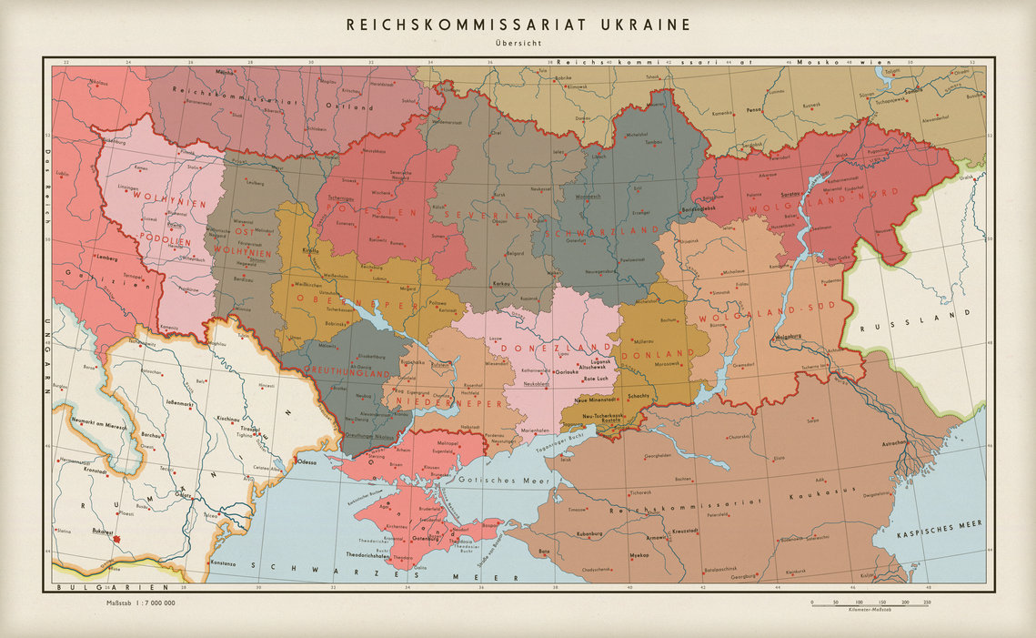
Reichskommissariat Украины и ее подразделения (Generalbezirke). Волынь-Подолье, Восточная Волынь, Полесие, Верхний Neper (Днепр), Нижний Neper и Greuthungland должны были быть заселены немцами как часть жизненного пространства Германии. Восточная часть Volgaland-севера была уже заселена немцами в 1700 и 1800-ые. Им позволили остаться, чтобы заселить территории граничащие с Россией (Советский Союз). Wolgaburg (Волжская Крепость) является городом на противоположном берегу места где стоял Сталинград . Этот город с населением в 400 000 жителей ( немцы) должен был обеспечить защиту южной границы.

Крупнейшие города на востоке (Wolgaburg, Saratau, Каракуль и т.д.) были связаны с Рейхом огромным автобаном и сетью железных дорог. Вдоль дорог и железных дорог были построены малые города и деревни, такие как Georghalden, Gremsdorf, Neukassel, Büznow, Bachten и Weißkirchen.
Украинским подданным, которые не были высланы в Сибирь пришлось работать на немецких фермах. Они должны были проживать в Generalbezirke Severia, Donezland, Blackland, Donland, Volgaland-южного и восточного Volgaland-севера. Этими областями не должен был быть Germanised, за исключением капиталов и других главных центров Автострады.
Приблизительно 1955-1960.
Изначальный текст
The Reichskommissariat of Ukraine and its subdivisions (Generalbezirke). Volhynia-Podolia, East Volhynia, Polesia, Upper Neper (Dniepr), Lower Neper and Greuthungland were to be settled with Germans as part of the Lebensraum concept. The eastern part of Volgaland-North had already been settled by Germans in the 1700 and 1800s. They were allowed to stay to secure the border with Russia (Soviet Union). Wolgaburg (Volga Fortress) is a city on the opposite shore of where Stalingrad once stood. This city of roughly 400 000 inhabitants (all Germans) were to secure the southern part of the border. It was also constructed as a major shoe-in-the-face to the Russians.
The major cities in the east (Wolgaburg, Saratau, Astrachan etc) were connected to the Reich by enormous Autobahns and a railwork network with the German gaige width. Along the way of these roads and railroads smaller German villages and towns were constructed such as Georghalden, Gremsdorf, Neukassel, Büznow, Bachten and Weißkirchen.
The Ukrainian nationals who were not deported to Siberia or forced to serve on German farms were herded to the east. They were to reside in the Generalbezirke of Severia, Donezland, Blackland, Donland, Volgaland-South and eastern Volgaland-North. These areas were not to be Germanised, except for the capitals and other major Autobahn hubs.
Circa 1955-1960.
The next map in this universe will be one of the whole European continent, showing the current state of affairs.


